 The water was on the road at the ends of Milroy and Sparling.
 Several houses on College Avenue were surrounded by water, and much of that water was flowing.
 Across street you can see how far up College Avenue the water came. To park by the water treatment plant, you had to drive through water.
By the way, the Jasper County Interim Report liked this little building, which houses Rensselaer Well #1, giving it a notable rating. It says, "Relatively detailed for a functional building, it was constructed about 1935." (The Report likes the municipal power plant even more.)
 As the above pictures suggests, pretty much all of Iroquois Park was under water. There was no access to the park building. To the right of the big tree you can see just the very top of a fencepost sticking out. The fencepost is about 18 inches high.
 Below is another picture of Austin Park. Notice that the water has risen up to the sign showing park plans, and the sign is creating a little wake.
 Here is a little video of the water going under the Washington Street Bridge. It would not be a good day to raft down the river.
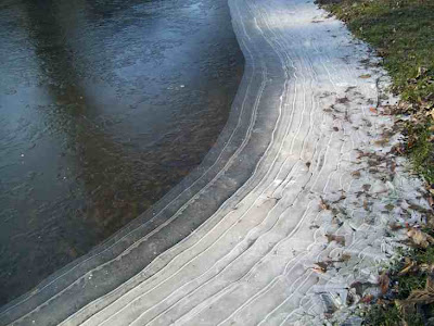
By Friday morning the water was starting to recede, as you can see from the ice in one pond that is at river level.
 Another place where the receding water was evident was on some of the trees, which had tiny ice skirts on them. This picture reminded me of much more impressive ice skirts from a smaller flood in January, 2005.
 The ice skirts from January, 2005 were impressive. I wish I had had a better camera to capture them.
 These 2005 pictures were taken between the College Avenue and the Washington Street bridges on the North side of the river.
 If the temperatures were in the single digits, we probably would be forming equally impressive ice formations this year. But I am happy to forego the ice formations for an early onset of spring.
 The gauging (or gaging) station had the river level at 15.4 feet at 6:00pm on Friday. It should slip below 15 feet on Saturday.
Update: It was at 14.96 at 7:30 on Saturday morning, 14.08 at 6:30 Sunday morning, and 12.97 at 7:30 Monday morning.


2 comments:
Ice skirts-a new term for me that totally describes what it is. I loved your water collection, but I am glad to see College Avenue open.
love the ice photos; shame about the flood damage
Post a Comment