Tuesday, April 27, 2010
City Auction
On Friday, April 23, the city of Rensselaer held an auction in front of city hall. Various city departments (cemetery, gas/water/street departments, volunteer fire department, mayor's and building commissioner's offices, police department, park board and utility office) were offering surplus office equipment, tools, and other things. Taking up most space were the bikes from the police department. I was interested in seeing what they had--four bikes were stolen last summer from my garage, and I wondered if any had turned up. I saw one that might have been one of the purloined bikes, but how can you really tell if you do not have a name or number engraved on it?

I was unable to get to the auction when it started, and when I did arrive, it was raining slightly and the bikes had all been sold. The crowd was small and it seemed that the prices were quite reasonable.

What are the chances of ever getting a stolen bike back? A few of those 80+ bikes may have been lost, but most were probably stolen, ridden a short distance, and abandoned. I can see why the police department does not put much effort into solving these thefts--many of the bikes, such as mine, are almost worthless. And how do you identify a bike--within the make, they all look alike.
Monday, April 26, 2010
Holley Savanna
The Holley Savanna in Newton County has been one of the spots I have wanted to see for about year, and during the weekend after Easter I finally got a chance to visit it. I was a bit concerned about what I would find after reading this description online:
The part along Newton County Road 100S looks like it is being restored to prairie. This was probably the cornfield mentioned in the first passage above.
I am not sure what this grass is, but I think it is one that NICHES uses in their prairie restorations. It is eventually disappears as the plants that they want there come into their own.
The picture below, like the picture above, was taken by my daughter-in-law, who likes to take these kind of pictures and has a camera that can do it.
Contrary to the articles I read, there was a path into the woods and it continued in the woods. It starts near the north east corner of the North Star Cemetery.
The path goes through many brambles, so it might have a lot of berries in a couple of months. Also along the trail were patches of mustard garlic, one of the invasive species that the naturalists hate. (But it is edible.)
The trail may be an animal trail because I doubt if many people use it. It eventually ends at a seasonal pond that had croaking frogs or toads. It was possible to bushwhack to a road just beyond the pond.
The little ponds in the area were full of life. My daughter-in-law had a polarizing filter that allowed her to take pictures of what was in them. There were a lot of mosquito larvae, so this place may be a lot less inviting in a month.
These flowers were in the cemetery next to the preserve. (The cemetery will be the subject of some future post.)
If you have the right kind of camera, you can take pictures of ladybugs that look professional.
This beetle was hiding under some bark that came off a log as we lifted it to see what, if anything, was living underneath. Even if you do not like bugs, you have to admit that this beetle is pretty, don't you?
To reach Holley Savannah from Rensselaer, go west on SR114 until you reach SR55. Turn north toward Mt Ayr, and follow SR55 until you reach Newton County road 100S. Turn west and continue until you reach the North Star Cemetery.
Alternatively, go north on US 231 until you reach Jasper County Road 200S. Turn west and go about ten miles. When you will go over the Interstate and past the Burr Oak Mennonite Church, you are over half way there.
Mixed woodland and savanna with a stream; supposed to harbor wildlife. Probably good for wildflowers through spring and fall because of the different habitats. 79 acres, no trails, and none too easy to walk through. A large area in front of the savanna is apparently farmed, although it has Nature Conservancy signs around it. Frankly, I'd take a pass on this and visit Stoutsburg Savanna or Tefft Savanna.At one time this was a property owned by the Nature Conservancy, and they still have a web page for it, which tells what you can see here:
A diverse selection of plants and animals, some which are endangered or threatened, make their home at the Holley. In the seasonal, vernal pools the freshwater fairy shrimp lives his whole life there while the tiger salamander makes it their breeding ground along with the chorus frogs, spring peepers and leopard & gray tree frogs. If you're lucky, you may spot the slender grass lizard - a special concern specie in Indiana - or the primrose-leaved violet, a state-threatened plant.As the sign now indicates, the property is now part of NICHES Land Trust. It was transferred in December, 2005. (The white fence behind the sign separates the nature preserve from the North Star Cemetery.)
The part along Newton County Road 100S looks like it is being restored to prairie. This was probably the cornfield mentioned in the first passage above.
I am not sure what this grass is, but I think it is one that NICHES uses in their prairie restorations. It is eventually disappears as the plants that they want there come into their own.
The picture below, like the picture above, was taken by my daughter-in-law, who likes to take these kind of pictures and has a camera that can do it.
Contrary to the articles I read, there was a path into the woods and it continued in the woods. It starts near the north east corner of the North Star Cemetery.
The path goes through many brambles, so it might have a lot of berries in a couple of months. Also along the trail were patches of mustard garlic, one of the invasive species that the naturalists hate. (But it is edible.)
The trail may be an animal trail because I doubt if many people use it. It eventually ends at a seasonal pond that had croaking frogs or toads. It was possible to bushwhack to a road just beyond the pond.
The little ponds in the area were full of life. My daughter-in-law had a polarizing filter that allowed her to take pictures of what was in them. There were a lot of mosquito larvae, so this place may be a lot less inviting in a month.
These flowers were in the cemetery next to the preserve. (The cemetery will be the subject of some future post.)
If you have the right kind of camera, you can take pictures of ladybugs that look professional.
This beetle was hiding under some bark that came off a log as we lifted it to see what, if anything, was living underneath. Even if you do not like bugs, you have to admit that this beetle is pretty, don't you?
To reach Holley Savannah from Rensselaer, go west on SR114 until you reach SR55. Turn north toward Mt Ayr, and follow SR55 until you reach Newton County road 100S. Turn west and continue until you reach the North Star Cemetery.
Alternatively, go north on US 231 until you reach Jasper County Road 200S. Turn west and go about ten miles. When you will go over the Interstate and past the Burr Oak Mennonite Church, you are over half way there.
Sunday, April 25, 2010
Going to church United in Morocco
(I thought it would be interesting to use Sundays to focus on Rensselaer area churches and to see how many Sundays I can go before I run out of material. Indiana is richly endowed with religious denominations, with influences from North and South, East and West. This is part of that series of posts.)
The United Church of Morocco is located at College and Main in Morocco. It is not listed in the "Church Services Directory" of the Rensselaer Republican, and it does not seem to have a website other than a Facebook page, which says that their worship hour on Sundays is at 10 a.m. and that they have Sunday School at 9. I did not find the name of the pastor.
An explanation of the name of the church is given on one of their Facebook pages:
Morocco has an United Church that combines two separate denominations, and two separate congregations of the United Methodists. It clearly is an interesting town from the point of view of religion.
The United Church of Morocco is located at College and Main in Morocco. It is not listed in the "Church Services Directory" of the Rensselaer Republican, and it does not seem to have a website other than a Facebook page, which says that their worship hour on Sundays is at 10 a.m. and that they have Sunday School at 9. I did not find the name of the pastor.
An explanation of the name of the church is given on one of their Facebook pages:
The United Church of Morocco is truly a church that is bound together with the love of Christ and one another. It began in 1971 as a union of the believers of the Morocco Baptist Church (American Baptist) and the Morocco Christian Church (Disciples of Christ).They are listed as an American Baptist church using the Find-a-church search at the American Baptist site. Wikipedia has information about this denomination, a denomination I do not recall meeting previously in previous Sunday postings. In Indiana, Franklin College has its origins in this denomination. We have met the Disciples of Christ; they are the denomination of the First Christian Church in Rensselaer. However, searching the denominations website for local churches does not return the United Church of Morocco.
Today, though both denominations are equally supported through mission funds, it is difficult to identify any denominationalism within the United Church family. As a result of this unusual combination of differing backgrounds, a unity of the Spirit exists that is difficult to find anywhere in the churches of today.
Morocco has an United Church that combines two separate denominations, and two separate congregations of the United Methodists. It clearly is an interesting town from the point of view of religion.
Saturday, April 24, 2010
Give me an A
I have come to realize that whenever I see workers dangling from ropes or in buckets high overhead, I feel compelled to stop and take a picture. I have at least mild acrophobia, or fear of heights, so I admire and envy the people who can work high above the ground and feel comfortable.
On Tuesday I posted some pictures of workers painting the city water tower south of town. On Wednesday I stopped by to see how work was progressing and thought the scene below was a bit different from what I had previously shown. Instead of being in the bucket coming from the ground, this worker was suspended in a cage being dropped from the top.
Someone has to do the boring job of painting the low spots.
On Thursday morning the workers were repainting the letters of the words Rensselaer, one on the north east and one on the south west. They began on the north east. As I was watching them finish up the final E, a worker emerged from the little trap door just below the tank and scooted along the rails. He got to the other side and then in some way he got to the top. I did not see what he did when he got to the back.
The outlines of the letters were still visible from the old paint job, though they may have put down a preliminary layer for some of the letters. Below a worker is beginning to outline the letter A. Notice how he is not on the bottom of the cage. I could not see if he was on the rail or had some other way to get as high as he was. When he got the outline partially finished, he would fill it in with a bigger brush or roller. Two workers were in the cage for this job.
It did not take long and half of the letter was painted on.
In early afternoon I stopped by again. The workers had begun the south west letters. I do not know how they chose which letters to do first. Here they began with the EL.
A few hours later they had finished the EL, and also the RE, an S, and part of the N and were ready to start on the AE.
One worker did as much of the E as he could reach while the other focused on the A.
I doubt if I will still be doing this blog the next time they paint this water tower.
Friday, April 23, 2010
Downtown Morocco
Though I have lived in Rensselaer for about 35 years, I do not recall ever visiting downtown Morocco. I have driven by it many times on US 41, and past it by continuing west on SR 114 to Willow Slough or Illinois. But a few weeks ago when I was in the area, I decided to see what was there.
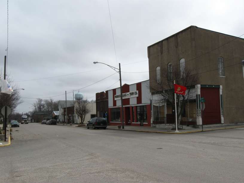
The downtown stretches for about two city blocks on either side of State Street, from Main Street to Lincoln. Here is the view from Main Street looking east. The DeMotte State Bank is on the right and it has a newer building. Almost everything else in the downtown is quite old.
The view below is also from Main Street looking east, but it shows the buildings on the north side of State Street. Most of these buildings seem to be occupied with either services or offices. The North Newton School Corporation has offices here. There is almost no retail left in downtown Morocco. I was there late on a Saturday morning and the downtown was dead.
A block to the east of Main Street is Clay Street. I liked the fountain and the clock at this intersection. The building with the big blue and white sign is the Newton County License Branch office. Next to it is a building on which the siding above the entrance is partially gone.
Morocco was platted in 1851. Few if any of the buildings from its earliest years survive. A railroad line of the Chicago and Eastern Illinois Railroad reached Morocco in 1888 and in 1905 the Chicago, Indiana, and Southern Railroad was constructed. Though the rails of the CI&S (which later was merged into New York Central) are still intact, the line has been abandoned. The late 19th and early 20th centuries were the most prosperous years in Morocco's history, and most of the buildings downtown were built in that era.
Below is a view from Clay Street looking west. It shows the same buildings that you can see in the second picture of this post.
Almost all the buildings that were in downtown Morocco a hundred years ago are still there. Unfortunately, none of them is really all that remarkable. The Newton County Indiana Historic Sites and Structures Inventory lists 16 buildings in this section of downtown Morocco, but not one of them is anything more than "contributing."
Looking east from the clock and the water fountain, here is the view of the south side of State Street. The most noticeable building is that of the Morocco Glass and Trim, a business that replaces automobile windows. It is not the sort of business you expect to find in a downtown.
Walking east on State and looking back, you can see a big sign that reads:
The buildings on north side of State Street east of Clay seem to be mostly vacant.
Because the old commercial district clings to State Street, you can get a clear picture of the backs of the buildings that are shown above.
The weathered sign for an old Pool Hall had interesting lettering.
At the end of the row of mostly vacant buildings is a small park, Betty Kessler Park. Under the roof on the left are paintings of history and highlights. One features Sam Rice, a Hall of Fame baseball player. Wikipedia notes:
This little park is where the Morocco Farmers' Market, which has a Facebook page, meets on Saturdays.
Old, decaying buildings give many opportunities for "artsy" photographs.
Little Indiana visited Morocco a while back and was not much impressed. See here and here for her account.
There is not a lot of information about Morocco on the Internet. A publication called the Morocco Times has a Facebook page, and does the town of Morocco. The Morocco Times has a web page of local links, of which the historical society site is the most interesting. Among other things, it has some very nice old maps.
Update April 26. The town of Morocco has a new website at http://www.townofmorocco.com/ .
The downtown stretches for about two city blocks on either side of State Street, from Main Street to Lincoln. Here is the view from Main Street looking east. The DeMotte State Bank is on the right and it has a newer building. Almost everything else in the downtown is quite old.
The view below is also from Main Street looking east, but it shows the buildings on the north side of State Street. Most of these buildings seem to be occupied with either services or offices. The North Newton School Corporation has offices here. There is almost no retail left in downtown Morocco. I was there late on a Saturday morning and the downtown was dead.
A block to the east of Main Street is Clay Street. I liked the fountain and the clock at this intersection. The building with the big blue and white sign is the Newton County License Branch office. Next to it is a building on which the siding above the entrance is partially gone.
Morocco was platted in 1851. Few if any of the buildings from its earliest years survive. A railroad line of the Chicago and Eastern Illinois Railroad reached Morocco in 1888 and in 1905 the Chicago, Indiana, and Southern Railroad was constructed. Though the rails of the CI&S (which later was merged into New York Central) are still intact, the line has been abandoned. The late 19th and early 20th centuries were the most prosperous years in Morocco's history, and most of the buildings downtown were built in that era.
Below is a view from Clay Street looking west. It shows the same buildings that you can see in the second picture of this post.
Almost all the buildings that were in downtown Morocco a hundred years ago are still there. Unfortunately, none of them is really all that remarkable. The Newton County Indiana Historic Sites and Structures Inventory lists 16 buildings in this section of downtown Morocco, but not one of them is anything more than "contributing."
Looking east from the clock and the water fountain, here is the view of the south side of State Street. The most noticeable building is that of the Morocco Glass and Trim, a business that replaces automobile windows. It is not the sort of business you expect to find in a downtown.
Walking east on State and looking back, you can see a big sign that reads:
Peoples Drug StoreSince there is no drug store there now and the sign looks recent, I assume that it recreates something of the past.
Everything to be found in an up to date drug store
Get the Peoples quality.
The buildings on north side of State Street east of Clay seem to be mostly vacant.
Because the old commercial district clings to State Street, you can get a clear picture of the backs of the buildings that are shown above.
The weathered sign for an old Pool Hall had interesting lettering.
At the end of the row of mostly vacant buildings is a small park, Betty Kessler Park. Under the roof on the left are paintings of history and highlights. One features Sam Rice, a Hall of Fame baseball player. Wikipedia notes:
Rice grew up in various towns near Morocco, Indiana, on the Indiana-Illinois border, and considered Watseka, Illinois, his hometown. In 1912, as he played with a minor-league baseball team in Galesburg, Illinois, Rice's wife, two children, mother, siblings, and a farmhand were all killed in a tornado that swept through Morocco. Rice's father Charles eventually succumbed to his storm-related wounds.In the background you can see one of the two elevators in Morroco. (The other is smaller and seems to be defunct.) It is surprising to see an elevator here because it is not next to railroad tracks. However, it may have once had railroad tracks when the Chicago and Eastern Illinois Railroad was in operation.
This little park is where the Morocco Farmers' Market, which has a Facebook page, meets on Saturdays.
Old, decaying buildings give many opportunities for "artsy" photographs.
Little Indiana visited Morocco a while back and was not much impressed. See here and here for her account.
There is not a lot of information about Morocco on the Internet. A publication called the Morocco Times has a Facebook page, and does the town of Morocco. The Morocco Times has a web page of local links, of which the historical society site is the most interesting. Among other things, it has some very nice old maps.
Update April 26. The town of Morocco has a new website at http://www.townofmorocco.com/ .
Subscribe to:
Posts (Atom)